Land of the Gods  Published by Frontier Publishing
& Adventures Unlimited Press. To order,
visit the store The Gododdin triangle
by Philip Coppens  Eildon Hills The area around the Firth of Forth, on the South coast, the area of the Lothians, belonged to a tribe which the Romans called the Votadini. The Votadini seemed to have been singled out, occupying a unique if not bizarre position with the Romans. They apparently welcomed the Roman invaders, who seem to have returned the favour. Indeed, the Romans apparently never really “invaded” the Votadini at all. If anything, they left the tribe largely the way it was. Even more bizarre: the so-called Traprain treasure, discovered on Traprain Law, the “capital” of the Votadini, consists of a hoard of Roman silverware. Archaeologists accept that the Romans paid the Votadini. Why? The situation south of the Firth of Forth, on the Eastern side of Scotland, was complex. The Votadini, or to give them back their own name, the Gododdin, ruled the Lothians and the coastline as far south as Berwick-upon-Tweed, where the river Tweed made for a natural border. Inland lived the Selgovae tribe. Driving from the Lothians to Melrose, the A68 follows the Roman road running North. Along the river Tweed lay Trimontium and the Eildon Hills. It is this river that continues eastward, before reaching the North Sea at Berwick-upon-Tweed. The Borders, by its name, is a border area, between Scotland and England; the Tweed is in both Scotland and England.
Though Traprain Law is the most famous hill fort of the Gododdin, there was another one, to the south of their territory, relatively close to the Eildon Hills, where there was a Selgovae hill fort. The Gododdin’s hill fort was located on Yeavering Bell, near the confluence of the rivers Glen and Till. All three hill forts are remarkable for their size: they are gigantic compared to other hill forts in the area, underlining their importance.
Yeavering Bell is the largest hill fort in Northumberland, enclosing some 5.2 hectares. Unlike Traprain Law or the Eildon Hills, Yeavering Bell does not stick out from its surroundings. The site is remote, the road at its foot barely used. Climbing to 1,182 feet, it is far higher than the other hill forts and from its summit, it offers the same spectacular views of the surroundings, in this case the Northumberland hills. It summit is a broad double peaked bulk, which dominates the north Cheviot foothills. Like Traprain Law and the Eildon Hills, it was formed in the Devonian period, some 350 million years ago in the violent volcanic eruptions which created the entire Cheviot range. While it is important to note that its position might seem out of the way, even a modern traveller realises it is far closer to everything than its remote aspect would at first suggest. As archaeologist Clive Waddington summarised, the Milfield basin forms the largest physically contained alluvial flood basin in Northumberland. It also straddles two key communication routes running north-south and east-west with the entrance to Glendale forming the junction of these two axes. Immediately overlooking this naturally defined cross-roads is the most prominent hill of the northern Cheviot rim: Yeavering Bell.  Is it possible that Yeavering Bell had sacred origins? The name is P-Celtic, being originally Ad Gefrin, which translates as Goat Hill. We know that the Gyre Carling was associated with goats, and as she was linked with primeval hills, are we confronted here with another primeval hill? Yeavering Bell There is archaeological evidence as well. Ad Gefrin, in the valley, began as a Neolithic cremation cemetery. The Coupland henge was orientated towards the twin peaks of the Bell; there are two henges in the Milfield basin, the crop marks of which can still be seen; along the banks of the river Glen is a standing stone, known as the Battle Stone; the eastern peak has a modern walkers’ cairn on top, but there was originally a Neolithic burial cairn on this site. This is all evidence that the area was a sacred landscape, with the Bell as its focus.
It is its twin-peaked shape that probably made it a likely candidate as a sacred hill. Such twin peaked hills are known to have been identified as sacred; it resembles other “breast shaped hills” such as the “Paps of Jura” and the Devil’s Gap. Furthermore, even though Yeavering Bell is not a “lone hill”, it does stand apart from the other Cheviot Hills. When viewed from the lower lying ground of the basin, it stands out most markedly against the southern horizon. Therefore, positioned at a key communication junction, and in the lee of the most prominent hilltop, Old Yeavering (Gefrin) clearly occupies a rather special place in the dramatic landscape of the Milfield basin. When I was preparing a field trip to Yeavering Bell, I had to locate it precisely on the map. At the same time, I wanted to map its relationship with the other two “capitals” in the region, Traprain Law and Eildon Hill. I literally drew lines on a map and it was to my utmost surprise that the angle between the line running from Eildon Hill to Traprain Law and Eildon Hill to Yeavering Bell was a perfect 90 degrees. I was so struck by this, that I drew it again, this time on another map, with a different scale.
Of course, plotting such items on maps is bound to contain some error, but even if it varies between 87 or 93 degrees, the discovery – I felt – was stunning. There are many hills, but these three hills were described as special in the literature, specifically because of their gigantic hill forts on top. Furthermore, they were all important at the same time, from the Neolithic well into the Iron Age. Two were operated by the same tribe, and the third, Eildon Hill, was the capital of the neighbouring tribe, the Selgovae.
The next question on my mind was: was this “triangle” the reason why these three natural hills, enigmatic hills at that, had been chosen as sacred hills?  Such discoveries are fraught with problems. Yes, it is a coincidence, and the question is whether our forefathers were aware of its “oddity” or whether we, 20th century educated modern men, see “things” that only 20th century educated modern men would see. Furthermore, the picture is complicated by the fact that when people have reported such potential discoveries in the past thirty years, the question on the observer’s mind may well be whether or not it involved extraterrestrial involvement, for we all “know” the Gododdin were stupid and could not have known many of the things that we know. How could the Gododdin have known about trigonometry? ET is phoned to solve the problem.
Though I have no theoretical objections to extraterrestrial suggestions, I do tend to think that the presentation of an enigma, or something that needs explaining, needs to be explained in terrestrial terms, rather than immediately turn to the “deus ex machina”, i.e. parading ET or Atlanteans. It is, I feel, an easy answer to difficult questions and rather than explain things, it calls more questions into existence. Why would aliens or Atlanteans be interested in telling the locals to create a triangle of hill forts? It would definitely not help aliens, and though it would be nice of our Atlantean forefathers to leave such a legacy, they could have done better things with their time, I feel. But let’s not run away too quickly. First of all, the question needs to be asked whether it was a coincidence. The answer seems to be no. It is a fact the Celtic tribes held these three hill-tops sacred and constructed defences on them. When you map those in the landscape, and you discover that lines between them form a perfect 90-degree triangle, it is hard to believe that this is chance or coincidence. Furthermore, the “triangle” is not just some random drawing on a landscape. The Traprain Law-Eildon Hill line formed the major axis of their territory, largely marking the border between the Selgovae and the Gododdin. Furthermore, the Eildon Hill-Yeavering Bell line formed the “first line of defence” against any invader from the south. Yeavering Bell was the southernmost fort of the Gododdin, and like Eildon Hill, it was built to ward off invaders from the south.
All three mark important points in the landscape: we have just observed the “crossroads” visible from Yeavering Bell; Trimontium shows the importance of the main road running north; from Traprain Law, you have a clear view of the coastline to the north, as well as the A1, which sits on top of a Roman road.
The Traprain Law-Yeavering Bell line seemed to be redundant, but in fact, it is not. The three sides describe an area contained within the triangle, which could be seen as “sacred space”. In pre-Celtic times, it might have been further evidence of “sacred landscape design”, marking out a sacred area belonging to a tribe. Thus the Traprain Law-Yeavering Bell “frontier” might mark the eastern border of their territory, even though I would argue that this was an artificial substitute for the natural border of the shore.
But the line was not redundant. The A1 always kept just outside this line and, most obviously, is literally within hundreds of yards north of Traprain Law. As such, it seemed that the A1 was deliberately located to remain outside the area enclosed by this triangle. Coincidence? Perhaps, but again, I think not. 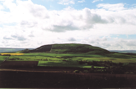 Traprain Law As mentioned, the A1 generally follows Roman roads, which in their turn normally followed existing prehistoric tracks. What was remarkable was that Dere Street, the A68, did enter the sacred territory, though only “just”; largely the A1 and the A68 reinforced the “Gododdin Triangle”, to give it a name. The area between both roads was largely the area described by the “Gododdin Triangle”. It overlaps with the area known to have been the Gododdin territory.
Coincidence or not? It is a fact that the ninety-degree angle is there; the question is whether our ancestors knew about it or not. Though they did not have space photography at their disposal, it is possible that in prehistoric times, when the Megalithic People mapped the sacred landscape, they did possess skills to measure the land. The question of whether they knew the properties of right-angled triangles is also important. Thom, in his analysis of stone circles and other megalithic monuments, stated that certain designs, specifically ellipses, flattened circles and egg-shaped circles, were constructed by using field geometry and surveying techniques, including the knowledge of right-angled triangles. Though there is an obvious difference in scale between working with such triangles over a few metres and over dozens of miles, there is also a commonality: stone circles defined a sacred space; from all accounts, it is clear that the Gododdin territory was equally considered to be as sacred space. Could it be that in the latter’s definition, a triangle – a triangulation – incorporating the main and highest peaks of the region was used?